Mobile application to manage public transport routes
Aplicación móvil para gestionar las rutas del transporte público
María Camila Sánchez-Velásquez, Kely Yineth Díaz-Pedroza, Dewar Wilmer Rico-Bautista
Ingeniera de Sistemas, mcsanchezv@ufpso.edu.co, Universidad Francisco de Paula Santander Ocaña, Ocaña, Colombia
Ingeniera de Sistemas, kydiazp@ufpso.edu.co, Universidad Francisco de Paula Santander Ocaña, Ocaña, Colombia
Magister en Ciencias Computacionales, dwricob@ufpso.edu.co, Universidad Francisco de Paula Santander Ocaña, Ocaña, Colombia
Recibido: Marzo 14 de 2020 Aceptado: Junio 22 de 2020
Forma de citar: M.C. Sánchez-, K. Diaz, D. Rico,“Aplicación móvil para gestionar las rutas del transporte público”, Mundo Fesc, vol. 10, no. 20, pp. 230-240, 2020
Autor de correspondencia:
*Correo electronico:
mcsanchezv@ufpso.edu.co
©2020. Fundación de Estudios Superiores Comfanorte.

Resumen
Las aplicaciones móviles inteligentes son aplicaciones de software que están diseñadas para funcionar con teléfonos, tabletas y otros dispositivos electrónicos móviles. Son fundamentales en nuestra sociedad actual, incluida la comunicación, la educación, negocios, entretenimiento, medicina, finanzas, viajes, servicios públicos, sociales y transporte. En esta última categoría las oportunidades que se han revelado incluyen la planificación de rutas, compartir viajes y coches, seguridad del tráfico, información sobre el estacionamiento, recopilación de datos sobre el transporte, emisiones de combustible y consumo, e información de viajes. El objetivo del desarrollo de la aplicación móvil es dar a conocer la información al usuario de cada microbús de acuerdo con la ruta de su preferencia. Se articula con un prototipo para un bus inteligente, el cual cuenta con una red de sensores y un sistema de posicionamiento global (GPS). La información de los sensores y el posicionamiento es centralizada a través de un Arduino, en el cual está cargado el proceso que permite conocer la cantidad de puestos disponibles, la ubicación y el cálculo de la distancia entre el usuario y el microbús, propiedad en los puntos de referencia de la georeferenciación entre el bus y el dispositivo móvil del usuario. Esto contribuye a la gestión de las rutas del transporte público en una población específica, logrando obtener información de vital importancia al conectar las diferentes aplicaciones que las personas usan en su cotidianidad, teniendo en cuenta variables principales como la velocidad, el tiempo y la distancia recorrida en una trayectoria determinada.
Palabras Claves: Ciudad inteligente; Movilidad vehicular; Red de sensores inalámbricos; Sistema de Posicionamiento Global; Tecnologías inteligentes.
Abstract
Smart mobile apps are software applications designed to work with phones, tablets, and other mobile electronic devices. They are very vital to our society today, including communication, education, business, entertainment, medicine, finance, travel, utilities, social services, and transportation. In the latter category, opportunities have been revealed that include route planning, car pooling and ride sharing, road safety, parking information, transportation data collection, emissions, fuel consumption, and travel information. The mobile application development aims to provide information to the user of each minibus based on their preferred route. It is articulated with a smart bus prototype, which has a network of sensors and a global positioning system (GPS). The information about the sensors and positioning are centralized through an Arduino, in which the process allows the users to know the number of available positions, location, and calculation of the distance between the user and microbus, based on the geo reference; reference points, are loaded between the bus and the user's mobile device. This contributes to the management of public transport routes in a specific population, obtaining vital information by connecting the different applications that people use in their daily lives, considering main variables such as speed, time and distance traveled on a given route.
Keywords: Smart City; Vehicular Mobility; Wireless Sensor Network; Global Positioning System; Smart Technologies.
Introduction
In recent years, the advancement of technology and the development of a great diversity of mobile devices equipped with sensors, has opened the possibility of living in an intelligent environment, where it seeks to understand how to use emerging technology to contribute to assertive decision making for all inhabitants. Nowadays it is common to involve these tools in the development of daily tasks, where it is possible to expose a wide interaction between people and new technological tools oriented to any area, from transportation to applications that seek to contribute to the maintenance of the environment [1].
Transportation has become an important axis for the development of cities, bus is widely adopted as the main transport system, it reduces pollution and is also economical in most cases, providing the possibility to move from one end of the city to another at an affordable cost [2], it is possible to find in some cities, cars that are better adapted to the needs of users; using intelligent systems, and other methods that indicate that traditional transport has evolved and has allowed re orienting its services, involving information, telecommunications, computers, sensors and other technologies to provide better services to passengers, allowing them to have realtime information about a particular car on a specific route, thus achieving a system with intelligent transport management [3].
Thus, more and more public transport companies are adapting global positioning system (GPS) devices to the fleet of buses to keep control over the route followed by each of them. [4], and obtain valuable information that allows them to provide a better experience during the use of their services thanks to the analysis of the patterns in the trajectory that they leave within the application [5], and thus optimize the service and make it much more personalized.
This encourages other cities to implement these technologies that facilitate the mobility of a passenger, one of the examples that can be found in the use of smart cards, which have real-time information, the establishment of stops with information relevant to the location, thanks to the global positioning system included in each vehicle, among others [6–9].
The issue of wanting to use a means of transport has always been a tedious process andevenmore sowhenit comes to mini-buses. Most people have used public transport at some point, either for a particular occasion or daily to go to work or school, it is a service that is used massively, however, there are disadvantages, such as overcrowding or lack of information about the route you want to take, on the other hand, at certain times it has become a tedious and stressful process, because the route that reaches a particular destination, no longer has seats available, or the route that passes with quotas is not reaching the requested destination [10–13]. The concept of smart cities has received a lot of attention lately, and this is partly due to the benefits and improved services it offers to all citizens, in the area of streamlining processes and contributing to decision-making and helping to improve the sustainability of transport, as it allows intelligent planning in buses and operational decisions [10], thanks to this type of system it is possible to monitor the routes most used and thus expand the fleet of buses for the most requested routes [11].
Public transport has a great impact within smart cities, as it is one of the most used means of transport to move from one place to another and involves specific features to operate in the best possible way, for example, the use of sensors in vehicles, GPS, smart boards at bus stops, with relevant information for the passenger [12–15]. The purpose of smart buses is to facilitate the mobility of people and goods within a city, which in turn generates six benefits: reduction of traffic, travel time, travel costs, pollution, noise pollution, and increased safety during the journey [14].
This research has been based on the creation of a smart bus prototype to efficiently manage the location and number of seats available on public transport routes specifically in the city of Ocaña, Colombia. The paper is organized as follows: the first section is an introduction to mobility with the use of technological tools and the literature review. The second section includes everything that has to do with the methodology used and the phases that were carried out to carry out the project. Finally, the conclusions of the process are presented, suggesting new research possibilities within this important topic such as intelligent transport.
Materials and Methods
Adescriptive methodology with aquantitative approach was used in the development of this research. The objective of this type of research is to know the situations, customs, and attitudes that prevail, through an accurate description of activities, objects, processes, and people. Thus, its objective is not limited to data collection, but also to predict and identify the relationships that exist between two or more variables [15]. In this way, researchers collect data based on a theory and use the information carefully [10], thus achieving the knowledge of the end user's needs and quantifying the data that can be provided through their mobile device [16].
To cover different perspectives, the project development will implement two agile methodologies, Scrum and prototypebased, to determine activities that will have assigned completion times and working groups that are responsible for developing them. The assignment of tasks will allow, the generation of new ideas and the working group to deliver improvements to the prototype, each revision will generate a potentially deliverable product. The development of this methodology in research occurs through four fundamental phases:
- Phase 1: Research and exploration of the environment. Construction of models, technologies, analysis of terms and concepts of the latest generation of intelligent transport. In this phase, the different tools to be used were studied, having as a fundamental premise their use in the public transport environment, which will be discussed in more depth in the following section.
- Phase 2: Creation of the test prototype for intelligent transport. Definition of functional and non-functional requirements
- Phase 3: Development of a mobile application for control and monitoring. Design of the interactive scheme based on technological tools.
- Phase 4: Evaluation of the results obtained.
Results and Disclosure
Currently, mobility is something that most cities want to improve due to high traffic congestion and the growing population. Developments in this field range from mobile applications to sensor networks that send signals by measuring parameters such as sound, humidity, among others, managed remotely and globally [17]. But it is not enough to talk about sensors, several communication systems are responsible for transporting these data to reach their destination, where they can be analyzed and can contribute to decision making for future applications [18]. Smart cities need mobility [19], and nowadays one of the default factors for mobility is time, sustainable urban transport solutions are of paramount use, allowing the best experience in any mobility in the shortest possible time [3], [20] [23], while this seems a great challenge in research, there are already several studies conducted to solve this problem; The whole world is in search of the best solutions for this type of problem, and for this, makes use of large sensor networks that capture what is happening and thus obtain more information subject to analysis by manipulation systems with Big Data [24]–[27]
Environmental research and exploration
This phase is developed with the use of interviews with managers, drivers, and users of the transport companies; interview with 2 managers of Cootrans Urbanos and Cootrans Hacaritama helped to determine the type of technological infrastructure the buses have, the distribution of routes, schedules, and frequency with which they opérate. In the case of the drivers it was possible to establish the relationship with the users at the moment of providing the service by conducting 10 surveys in different transport companies. 100 users were surveyed in which they were asked about their interest in the research and showed great interest with the idea of having a mobile application that provides information on routes, departure and arrival times of vehicles.
In the internal structuring of public transport in Ocaña, Norte de Santander, the routes to be followed for each particular route are defined, and although some of them share routes in the central area of the city, each one goes through specific neighborhoods, as shown in Figure 1. The route with the route Santa Clara, Marabel, Juan XXIII, and University has 3 main starting points, starting in the northern part of the city (Santa Clara) specifically in the upper left corner of the figure, runs through specific neighborhoods (Marabel and Juan XXIII) and finally reach the University. Throughout the journey and thanks to the GSM/GPRS M10 Quectel module located in the vehicle, information is sent in real-time of the location.
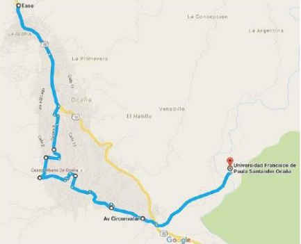
Figure 1. The trajectory was followed by the route of Santa Clara, Marabel, Juan XXIII, and the University.
For testing purposes in the present research u-Blox NEO-6M based GPS Module which has a supply voltage of 3-5 VDC, UART 5V serial interface, was used. EEPROM was used to store configuration data, signal indicator, and ceramic antenna to collect location information. For the use of this application, it is required to know the longitude and latitude, the Arduino electronic hardware board was used. To recognize and interpret the data sent the TinyGps library was used, for which it was initially required to import the IDE of the Arduino software and then make the respective modifications as the execution speed which must be modified from 115200 baud to 9600 baud as shown in Figure 2, and proceed with the loading of the program on the card.
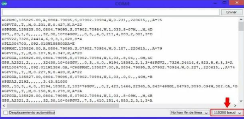
Figure 2. Configuring the GPS data reception rates in the Arduino tool
Test prototype for intelligent transport
After collecting the information through surveys, we proceeded to review the main tools for the realization of the prototype, the first key point to address was the choice of sensors and their suitability for a large-scale bus. In the case of the prototype, the sensors used were contact sensors, which when pressed sent information to a pic16F628 controller, this controller, has 8 pins and a maximum frequency of 20MHz, the pins can be used in various ways and are configured in the program, the controller is also based on CMOS FLASH and includes the powerful PIC architecture, has an internal oscillator of 4MHz, 128 Bytes of data memory. The information about the availability of seats is visible to the user through a liquid crystal display (LCD) located at the front of the vehicle, for the prototype was used the reference LCD Display 3.5'' 3.5 PuLG Arduino Uno Tft Ili9486 480x320 taking into account its compatibility with the Arduino board. The tests were carried out with the integration of each of the elements to be used as shown in Figure 3. Several communication systems are responsible for transporting this data until it reaches its destination, where it can be analyzed and can contribute to decision-making for future applications [18].
In the first instance, there is an input interface, which can be directly attached to the peripherals, or connected to them by ports, the purpose of this input interface, is to carry the information to the microcontroller, the part responsible for processing the data and has an output interface, which carries the processed information to the peripherals responsible for making the final use of the data, which in some cases may well be another board which centralizes and processes the information again [28].
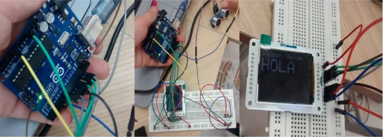
Figure 3. 3D simulation of the full-scale prototype.
After making the small-scale prototype, and testing connections, we proceed to make a fullscale prototype, which used tools such as GPS Module based on u-Blox NEO-6M, Proximity Sensor HC05, and LCD SD card reader. The information is administered and managed by an Arduino controller. The second prototype is focused on creating an internal wired network as shown in Figure 4 between the sensors of each of the vehicle's posts, which are programmed to activate and detect a person in the vehicle's seat thanks to the proximity sensor configuration, the consolidated information of all the posts and the location of the automotive is centralized in real-time by an Arduino controller after the analysis of the information received, the Arduino sends the information of the free seats to the LCD screen through which the people waiting for a bus can visualize the availability of seats, information that will also be visualized through the mobile application [9]. Figure 4 represents an approach of a full-scale prototype for use within a means of public transport such as the minibus, it is important to note that the wired network and the sensor will be located on top of the roof, this being a strategic point to achieve a better parameterization of the data collected by the sensor.
For programming starts from the ultrasonic sensor, which is encoded to be activated at a certain distance, in this case at twenty (20 cm) from its original location, when sending a signal, the code is running through two cycles, which evaluate which condition is met, and depending on this, a message is sent by screen of the availability of positions "1" or "0" The GPS is responsible for sending several variables, but in this particular case, only need, longitude and latitude, and to read the data that the GPS receives was necessary to import a library called TinyGps; to be able to use it is necessary to import it, copying it in the libraries folder, where the Arduino IDE is installed, and then restart the program so that it loads correctly; the library will correctly identify the longitude and latitude, without having to resort to complex algorithms; to do this, the library brings an example, called Simple_test, after running it, make sure that the execution speed is changed to 9600 baud, and the code of the card is loaded again.
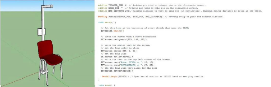
Figure 4. 3D simulation and programming of the sensor distance on the full-scale prototype.
Application development
The mobile application as shown in Figure 5, is a tool that will allow people who are waiting for a minibus to know the number of available seats, thus knowing the trajectories and estimated waiting times between each of the routes. [29], [30], the initial APK is focused on mobile phones with the Android operating system, and organized according to the main routes (Circunvalar, Marabel, Llano, Cementerio, Santa Clara). The application in its Version 1.0 works as follows, to start the user enters the application, in the first interface the user can see the list of routes that run daily in the city, according to their transfer needs to select the route that suits them, the application shows in the first version, the real-time location of the vehicles covering that particular route. The application is developed with App Inventor which is a software development environment created by Google Labs for the development of applications for the Android operating system.
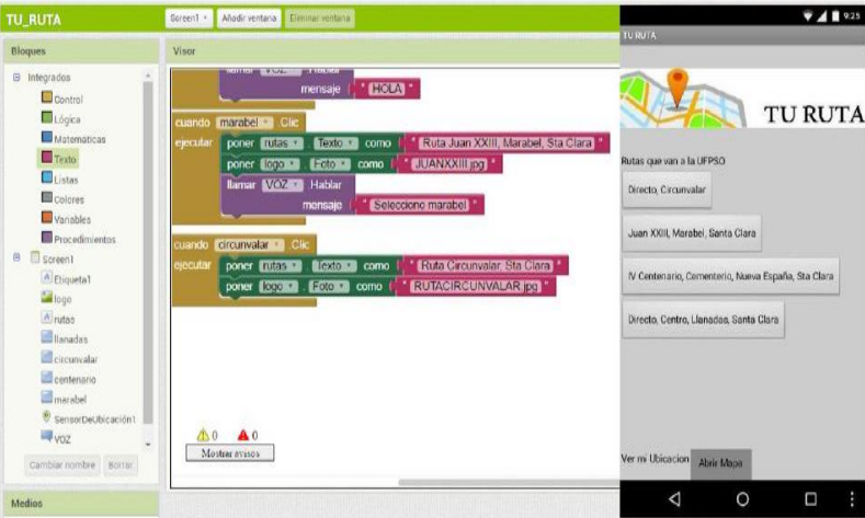
Figure 5. View of the main menu in the mobile application.
In Version 2.0 it is planned to add to the application the free seat counter, so that passengers can preview this information in real-time, along with the distance between the user and the position of the bus, highlighting this as a plus in terms of time management that users take to review the mobile application and choose the route that best suits their needs, it should be clarified that for the use of the application is necessary to grant location permissions [31]. Because an API of google maps is used to visualize the useful routes and also at the time of estimating the distance between the bus and the user since it will be taken as a reference to the location provided by the GPS of the microbus with the one provided by the GPS present in the user's mobile device.
Evaluation of the results obtained
Based on the development of research, it is necessary to mention that intelligent transport is one of the main technological advances that contribute to the development of a city, clearly counting on the application of technology in various fields, including the commercialization of agricultural products, technology is a tool that will promote trade by facilitating communication between producers and traders of agricultural products [32]. The intelligent transport application has a large number of tools that meet the objectives, such as the integration of mathematical formulas for the calculation of distances, the passage of these formulas to programming and / or coding within the different devices, and finally the interpretation of each. One of the data that is thrown to carry out the respective analysis.
Conclusions
Currently, the optimization of traffic and the use of public transport have become one of the elements to improve especially in cities where congestion occurs due to the high volume of vehicles and inadequate management of public transport. Based on the above premise various agencies have been implementing technological systems located in the streets as intelligent traffic lights, as well as public transport vehicles to meet the needs of drivers, thus achieving efficient and safe mobility. There are many devices and tools created for this purpose, based on control mechanisms, management, and operation of transport, most of these tools make use of global positioning systems (GPS) widely recognized for the advantages they offer for drivers, either in urban or rural areas, likewise, applications have been developed in different areas, One of the most significant uses is in the Intelligent Transportation System (ITS), which consists of electronics, communications, control and detection of all kinds of parameters in traffic to optimize efficiency through intrusive or non-intrusive sensors, these sensors provide traffic information such as speed, volume, density, individual vehicle classification, and others. Intelligent transport systems have proven to be an effective tool for the management and operation of transport, taking into account that transport is one of the main essential axes in the economy and the development of cities.
All these tools mentioned above allow useful information to be collected when calculating distances and estimated travel times, facilitating the process of using public transport, the application seeks to centralize all the information so that, in one place, the user can find information on the availability of seats, location of the bus, according to the established route, and the estimated time to reach the user's location. The adoption of technology in transport, involves improvements, like, the reduction of time at bus stops and proper time management when making use of public transport. The research promotes technological development and its integration with the axes of growth and the economy of a city.
Referencias Bibliográficas
[1] Z. Allam and Z. A. Dhunny, “On big data, artificial intelligence and smart cities,” Cities, vol. 89, no. January, pp. 80–91, 2019, doi: 10.1016/j.cities.2019.01.032
[2] S. R. Nalawade and S. Devrukhkar Akshay, "Bus tracking by computing cell tower information on Raspberry Pi," 2017, DOI: 10.1109/ICGTSPICC.2016.7955275
[3] S. H. An, B. H. Lee, and D. R. Shin, "A survey of intelligent transportation systems," 2011, DOI: 10.1109/ CICSyN.2011.76
[4] E. Tramontana and G. Verga, "Demo: Get spatio-temporal flows from GPS data," 2018, DOI: 10.1109/ SMARTCOMP.2018.00058
[5] J. C. Nobre et al., “Vehicular SoftwareDefined Networking and fog computing: Integration and design principles,” Ad Hoc Networks, vol. 82, pp. 172–181, 2019, doi: 10.1016/j.adhoc.2018.07.016
[6] X. Yang and L. Zhang, "A dynamic method to monitor public transport based on smart card and GPS Data," 2014, DOI: 10.1109/ ITSC.2014.6957807
[7] S. Šurdonja, T. Giuffrè, and A. DelukaTibljaš, "Smart mobility solutionsnecessary precondition for a wellfunctioning smart city," 2020, DOI: 10.1016/j.trpro.2020.03.051
[8] Z. Wei, Y. Song, H. Liu, Y. Sheng, and X. Wang, "The research and implementation of GPS intelligent transmission strategy based on on-board Android smartphones," 2014, DOI: 10.1109/ ICCSNT.2013.6967324.
[9] W. Loga-Księska, J. Sordyl, and A. Ryguła, “Long-term urban traffic monitoring based on wireless multisensor network,” Open Eng., 2020, DOI: 10.1515/eng-2020-0018
[10] A. J. Kadam, V. Patil, K. Kaith, D. Patil, and Sham, "Developing a Smart Bus for Smart City using IOT Technology," 2018, DOI: 10.1109/ ICECA.2018.8474819
[11] H.-X. Hu, B. Tang, Y. Zhang, and W. Wang, “Vehicular Ad Hoc Network Representation Learning for Recommendations in Internet of Things,” IEEE Trans. Ind. Informatics, vol. 16, no. 4, pp. 2583–2591, Apr. 2020, DOI: 10.1109/TII.2019.2929108
[12] T. Tang, R. Liu, and C. Choudhury, “Incorporating weather conditions and travel history in estimating the alighting bus stops from smart card data,” Sustain. Cities Soc., 2020, DOI: 10.1016/j.scs.2019.101927
[13] D. H. Mrityunjaya, N. Kumar, Laxmikant, S. Ali, and H. M. Kelagadi, "Smart transportation," 2017, DOI: 10.1109/I-SMAC.2017.8058235
[14] A. K. Debnath, H. C. Chin, M. M.Haque, and B. Yuen, “A methodological framework for benchmarking smart transport cities,” Cities, 2014, DOI: 10.1016/j.cities.2013.11.004
[15] R. Salazar-Cabrera and A. Pachon, “Methodology for Design of an Intelligent Transport System (ITS) Architecture for Intermediate Colombian City,” Ing. Y Compet., vol. 21, no. 1, Mar. 2019, DOI: 10.25100/iyc.v21i1.7654
[16] K. Y. Diaz Pedroza, B. Y. Chindoy Chasoy, and A. A. Rosado Gómez, “Review of techniques, tools, algorithms and attributes for data mining used in student desertion,” J. Phys. Conf. Ser., vol. 1409, p. 012003, Nov. 2019, DOI: 10.1088/1742-6596/1409/1/012003
[17] V. Kumar, G. Sakya, and C. Shankar, “WSN and IoT based smart city model using the MQTT protocol,” J. Discret. Math. Sci. Cryptogr., 2019, DOI: 10.1080/09720529.2019.1692449
[18] R. Aquino Santos, A. GonzálezPotes, L. A. Villaseñor Gonzalez, A. Crespo, J. Sanchez, and J. R. Gallardo, “Simulación de Algoritmos para regular el Flujo Vehicular y la Comunicación entre Vehículos Móviles Autónomos utilizando Redes Ad Hoc,” Rev. Iberoam. Automática e Informática Ind. RIAI, 2009, doi: 10.1016/s1697-7912(09)70078- 0
[19] C. D. Guerrero and D. Rico-Bautista, “Center for Excellence and Internet Acquisition of Things: A commitment to competitiveness from alliances between government, academia and productive sector,” RISTI - Rev. Iber. Sist. e Tecnol. Inf., vol. 2020, no. E28, pp. 615–628, 2020
[20] P. Andersson and L.-G. Mattsson, “Service innovations enabled by the ‘internet of things,’” IMP J., 2015, DOI: 10.1108/imp-01-2015-0002
[21] J. A. Parra Valencia, C. D. Guerrero, and D. Rico-Bautista, “IOT: una aproximación desde ciudad inteligente a universidad inteligente,” Rev. Ingenio, vol. 13, no. 1, pp. 9–20, Jun. 2017, doi: 10.22463/2011642X.2128
[22] D. Rico-Bautista, Y. Medina-Cárdenas, and C. D. Guerrero, “Smart University: A Review from the Educational and Technological View of Internet of Things,” in International Conference on Information Technology and Systems, ICITS 2019, vol. 918, P. M., F. C., and R. A., Eds. Systems and Informatics Department, Universidad Francisco de Paula Santander Ocaña, Algodonal Campus Vía Acolsure, Ocaña, 546551, Colombia: Springer Verlag, 2019, pp. 427–440
[23] M. Gheisari, G. Wang, W. Z. Khan, and C. Fernández-Campusano, “A contextaware privacy-preserving method for IoT-based smart city using Software Defined Networking,” Comput. Secur., vol. 87, p. 101470, 2019, doi: 10.1016/j. cose.2019.02.006
[24] P. Del Vecchio, G. Secundo, Y. Maruccia, and G. Passiante, “A system dynamic approach for the smart mobility of people: Implications in the age of big data,” Technol. Forecast. Soc. Change, vol. 149, no. October, p. 119771, 2019, doi: 10.1016/j.techfore.2019.119771
[25] D. Rico-Bautista et al., “Smart university: Key factors for the adoption of internet of things and big data,” RISTI - Rev. Iber. Sist. e Tecnol. Inf., vol. 201, no. 41, pp. 63–79, 2021, DOI: 10.17013/ risti.41.63–79
[26] Y. C. Wu, Y. J. Wu, and S. M. Wu, An outlook of a future smart city in taiwan from post-internet of things to artificial intelligence internet of things. Elsevier Inc., 2019
[27] M. Ghobakhloo and N. T. Ching, “Adoption of digital technologies of smart manufacturing in SMEs,” J. Ind. Inf. Integr., vol. 16, p. 100107, 2019, doi: 10.1016/j.jii.2019.100107
[28] H. Askari, A. Khajepour, M. B. Khamesee, and Z. L. Wang, “Embedded self-powered sensing systems for smart vehicles and intelligent transportation,” Nano Energy, vol. 66, p. 104103, 2019, doi: 10.1016/j.nanoen.2019.104103
[29] D. Rico-Bautista, E. BarrientosAvendaño, F. R. Cuesta-Quintero, L.A. Coronel-Rojas, J. Trillos-Arenas, and D. Hernadez-Villamizar, “Mobile application for the optimization of milk production and goat feeding processes: Experimental farm of Universidad Francisco de Paula Santander, Ocaña, Colombia,” J. Phys. Conf. Ser., vol. 1388, p. 012028, Nov. 2019, doi: 10.1088/1742- 6596/1388/1/012028
[30] L. A. Coronel-Rojas, D. Rico-Bautista, F. Cuesta-Quintero, E. A. P. Villadiego, and E. Barrientos-Avendaño, “Software móvil para reconocimiento, seguimiento y control de las plantas del vivero inteligente de la Universidad Francisco de Paula Santander Ocaña,” Rev. Colomb. Tecnol. Av., vol. Volumen 1, no. 33, 2019, doi: 10.24054/16927257.v33. n33.2019.3329
[31] D. Rodríguez Ibarra and M. Bobrek Fernández, “Aplicación móvil apoyada en georeferenciación que permita optimizar el uso del transporte público en la ciudad de cúcuta (STOPBUS),” Mundo Fesc, vol. 0, no. 11, pp. 48–55, 2016
[32] K. Y. Sánchez Mojica , J. E. Herera Rubio, M. Martínez Parada y L. A. Pérez Dominguez, Aplicación móvil como estrategia para la comercialización de productos agropecuarios", Respuestas, vol. 23, nº 1, pp. 52-59, 2018